


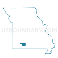
CHADWICK Voting District, Christian County, Missouri
About
Outline

Summary
| Unique Area Identifier | 607475 |
| Name | CHADWICK Voting District |
| County | Christian County |
| State | Missouri |
| Area (square miles) | 19.87 |
| Land Area (square miles) | 19.87 |
| Water Area (square miles) | 0.00 |
| % of Land Area | 99.99 |
| % of Water Area | 0.01 |
| Latitude of the Internal Point | 36.91282460 |
| Longtitude of the Internal Point | -93.03822450 |
Maps


Graphs
Select a template below for downloading or customizing gragh for CHADWICK Voting District, Christian County, Missouri


Neighbors
Neighoring Voting District (by Name) Neighboring Voting District on the Map
- GARRISON Voting District, Christian County, MO
- LEAD HILL Voting District, Christian County, MO
- NORTH LINN Voting District, Christian County, MO
- OLDFIELD Voting District, Christian County, MO
- SOUTH LINN Voting District, Christian County, MO
- SPARTA Voting District, Christian County, MO
Top 10 Neighboring County Subdivision (by Population) Neighboring County Subdivision on the Map
- Sparta township, Christian County, MO (2,719)
- North Linn township, Christian County, MO (889)
- Oldfield township, Christian County, MO (514)
- Chadwick township, Christian County, MO (409)
- South Linn township, Christian County, MO (238)
- Garrison township, Christian County, MO (197)
- Lead Hill township, Christian County, MO (148)